Pictured Rocks National Lakeshore Camping
notifications Text me when there's a cancellation at Pictured Rocks National Lakeshore


Pictured Rocks National Lakeshore
Pictured Rocks National Lakeshore
Pictured Rocks National Lakeshore
Pictured Rocks National Lakeshore
Pictured Rocks National Lakeshore
Sandstone cliffs, beaches, waterfalls, sand dunes, inland lakes, deep forest, and wild shoreline beckon you to visit Pictured Rocks National Lakeshore. The power of Lake Superior shapes the park's coastal features and affects every ecosystem, creating a unique landscape to explore. Hiking, camping, sightseeing, and four-season outdoor opportunities abound.
Pictured Rocks National Lakeshore is a U.S. National Lakeshore in the Upper Peninsula of Michigan, United States. It extends for 42 mi (68 km) along the shore of Lake Superior and covers 73,236 acres (114 sq mi; 296 km2). The park has extensive views of the hilly shoreline between Munising and Grand Marais in Alger County, with picturesque rock formations, waterfalls, and sand dunes.
Pictured Rocks derives its name from the 13 miles (24 km) of colorful sandstone cliffs northeast of Munising. The cliffs reach up to 200 feet (60 m) above lake level. They have been naturally sculptured into a variety of shallow caves, arches, and formations resembling castle turrets and human profiles. Near Munising, visitors can also visit Grand Island, most of which are included in the separate Grand Island National Recreation Area.
The U.S. Congress designated Pictured Rocks the first national lakeshore in the United States in 1966. It is governed by the National Park Service (NPS), with 22 year-round NPS employees as of May 2006, and received 1.31 million visitors in 2021.
Read more about Pictured Rocks National Lakeshore at Wikipedia
We can help! Many campsite reservations are cancelled daily. Just tell us when you’d like to camp at Pictured Rocks National Lakeshore, and how long you want to camp for. We’ll text you when a suitable spot opens up!
Scan for cancellationsWhoops! Sometimes we make mistakes. Want to help improve the Pictured Rocks National Lakeshore listing? Please suggest a correction.
Open to camping at other nearby parks? Here are a few other parks you'll find in the vicinity.
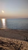
Close to the beach, no bugs, great hiking

We absolutely loved this campground. Just make sure to bring enough firewood into the park because the closest place that sells firewood is a 15-20 minute drive and closes right when you'd realize you don't have enough firewood at sundown.
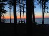
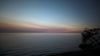
The campground faces northwest overlooking Lake Superior, so make sure you get there with plenty of time to get set up and settled so you can go down to the beach and enjoy the sunset over the lake.
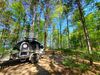
The sites are hard to come by but when you get one, you'll be so glad you did. Stay on the Lake Superior side of the campground (I was in site 28) and you'll find you have a huge site with a trail down to the beach about 50 yards away. It's primitive camping with a pit toilet and no camp hosts but you don't need any of that to enjoy a stunning sunset.
Tell us when, where, and how long you want to camp for. We’ll notify you (via SMS) when a suitable spot opens up at that campground—so you can nab that sold-out campsite reservation!
We love camping, and want to help you reserve the perfect campsite!